|
Directions
 Click image to view map. Click image to view map.
[Click here to download printer-friendly PDF version]
MILEMARKERS from Washington, D.C. to Scientists' Cliffs, Maryland
(Written for John and Julie Campbell by Donald Dahmann, neighbor and professional geographer)
MILEMARKERS provides directions from the District of Columbia to Scientists' Cliffs, Maryland. Scientists' Cliffs is a residential community that was established in the 1930s as a summer and weekend place-of-remove from Washington. It initially consisted of a cluster of log cabins which folks rented by the week. Since the 1930s, it has evolved to, first, accommodate the construction of cabins on private lots, and eventually to include year-round residents dwelling in pretty much anywhere-style structures, but still featuring wood.
Scientists' Cliffs is located on the Chesapeake Bay's western shore in Calvert County, Maryland. It lies within the immediate vicinity of Port Republic, a dispersed hamlet of structures that are situated within a few miles of each other - (former) general store, (former) school, church (originally Anglican, now Episcopalian), post office, gas station, tavern, farms, and residences.
MILEMARKERS describes a route that passes east-southeast along Maryland Route 4 from the southeastern side of the Washington Beltway (Interstate 95/495). While driving to Scientists' Cliffs, you will see elements of the long-established but now dramatically declining agricultural economy. It was based on tobacco and grain products - particularly corn - and the fruits of the bay - fish, crabs, oysters, eels, and clams - that extended from initial British colonization in the 1630s into the 1970s. More prominent today, as you will witness, is the development of large-lot Anywhere-USA exurban/suburban residences and their associated service expectations (yes, including Starbucks) now overwhelming the agriculture-based economy and landscape.
The first Europeans to see this corner of the world were members of an English expedition led by Captain John Smith in 1608. That expedition named what is now called Calvert Cliffs along Calvert County's bayside, Richard's Cliffs on the map that they prepared. The community of Scientists' Cliffs is situated along two miles of this landform. Initial European-American settlement of this portion of the Chesapeake focused on the flat, rich, bottomlands along the Patuxent River, the western side of the county, which remains prime agricultural farmland.
Well into this century, the flat waters of the Patuxent River and Chesapeake Bay served as the principal transportation route linking this portion of Southern Maryland to the rest of the world. Maryland Route 4, a divided four-lane highway and Calvert County's only major transportation artery, is actually relatively new, and passes through what was long the county's backyard. It links the county's major commercial centers - Dunkirk, Prince Frederick, and Solomon's Island - to each other, and more importantly today, it connects county residents with Annapolis, Baltimore, and Washington to the north, and with the rapidly developing Patuxent River Naval Air Station in St. Mary's county to the south.
Calvert County has experienced a surge in commercial development and a dramatic increase in its residential population since 1970, when the leading edge of Washington's suburban development rolled across its northern border. In 1950, the county was home to 12,000 residents, not much different from the 9,000 residents living here 160 years earlier when the nation's first population census was taken in 1790. From 1950 to 1970, the number of residents increased 75%, then 67% during the 1970s, 48% during the 1980s, 45% during the 1990s, and now stands at over 75,000. Within the Washington metropolitan region, only Virginia's Loudon and Stafford counties have experienced similar rapid population growth rates. As with other exurban counties in growing metropolitan regions, most of Calvert County's new residents work outside it.
Brief Directions:
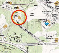
(1) from the Washington Beltway (Interstate 95/495) Exit 11, drive 35.4 miles east-southeast on Maryland Route 4, a 4-lane divided highway; (2) turn left onto Parkers Creek Road, about 5 miles south of Prince Frederick; (3) turn right onto Scientists' Cliffs Road, 0.5 miles from Route 4; (4) turn right into Gate A of Scientists' Cliffs, 2.2 miles from Parkers Creek Road; (5) turn left onto Apple Road shortly after entering Gate A; (6) turn right onto Arrowhead Road. 2432 Arrowhead Road is the second house on the right.
Long Directions:
Notes: "R" and "L" in the directions that follow indicate that the mentioned feature is located to the right or left of the main road (Maryland Route 4) when driving to Scientists' Cliffs from the traffic light at the Starting Point. Unique points of interest are indicated with a star (*). The starting point (Mile 0.0) for these directions, and the point-of-measure for the listed mileages, is the first traffic light on Maryland Route 4 east of the Washington Beltway - Getting to Starting Point (Mile 0.0): (1) from D.C. via Pennsylvania Avenue - head east on Pennsylvania Avenue, which becomes Maryland Route 4 at the District of Columbia-Maryland state line; continue past the Washington Beltway (I-95/495) to Mile 0.0; (2) from D.C. via South Capitol Street - on South Capitol Street, cross the Anacostia River; exit (left) onto Suitland Parkway; continue on Suitland Parkway past the Suitland Federal Center (L) and Andrews Air Force Base (R); turn right at terminus of Suitland Parkway, which is Maryland Route 4; start at Mile 0.6; (3) from North or South via Washington Beltway (I-95/495)--take Exit 11 to "Upper Marlboro Maryland/ Route 4" to Mile 0.0. Driving directly from the Beltway to Scientists' Cliffs will take under one hour; have a great drive!
MILE
0.0 Starting Point: set your vehicle odometer to 0.0 at first traffic light on Maryland Route 4, east (just outside) of the Washington Beltway (Interstate 95/495)
0.5 R - Suitland Parkway (Maryland Route 337) to Andrew's Air Force Base and D.C.
1.3 R - Dower House Road: Tucker's and Meadow's restaurants, basic Prince Georges County eateries, also gas and diesel fuel
5.7 R - Old Crain Highway (Maryland Route 725): exit to Upper Marlboro, the seat of government for Prince Georges County, established in 1706. The Show Place Arena and Prince Georges Equestrian Center (right) is an acknowledgement of horses in the area's previous economy for work and recreation. If you take this exit, you will see many structures that pre-date Route 4's bypassing of the town. They were typical of trade centers that served Southern Maryland's long-flourishing tobacco-based agricultural economy: large tobacco warehouses, auction houses, and farm-related in-town businesses, plus the tomb of William Beanes, who was held as a prisoner of war during War of 1812 and who Francis Scott Key was seeking to visit when he observed the bombardment of Ft. McHenry in Baltimore Harbor. Continue on Maryland Route 725 through town; turn right (south) on U.S. Route 301; exit to right (south, Prince Frederick) at Maryland Route 4, which returns you to the 'main' road to Listening Point at Mile 7.2
6.7 R - Direct exit to Upper Marlboro
7.2 U.S. Route 301 (Crain Highway to Baltimore and to Richmond, Virginia): commercial development associated with Upper Marlboro; shopping center to south
8.8 Bridge across the Patuxent River, which runs south along western side of Calvert County to enter the Chesapeake Bay at Solomon's Island; tidal wetlands in Patuxent River Park and Jugg Bay, just south of here, are great for canoeing/kayaking; British troops landed here to initiate ground assault on Washington, D.C. during War of 1812; enter Anne Arundel County
9.0 R - Maryland Route 408 to Wayson's Corner and Annapolis. Wayson's Corner is the site of a major bingo emporium, complete with its own bus service to Washington, D.C.; food; tobacco warehouses (no longer filled with tobacco), fresh produce and crab stand; gas
11.3 R - Maryland Routes 258 and 259 to Deale, a town on Chesapeake Bay
12.9 R - Park and Ride: parking lots provided by county governments for exurban residents who commute to work elsewhere in Washington metropolitan area (filled during the week)
13.2 R - Grain elevators (for corn) of the Southern States Cooperative
13.5 L - Maryland Route 260 to Chesapeake Beach and North Beach: two towns on Chesapeake Bay with charter fishing, restaurants, railroad museum, Tyler's Tackle Shop (smoked fish*). Enter Calvert County - pronounce the 'Cal' portion of Calvert like Cal in Cal Ripken if you are an outsider or nouveau, but 'Cal' as in culvert (a ditch for carrying away water) if you are a 'real' or long-term local (e.g., title to the land you own here has been in your family since receiving it by a grant from someone on the other side of the Atlantic Ocean)
14.3 Washington-oriented suburban/exurban residential development dating from the 1980s extends south from here throughout Calvert County. Relic wooden barns remain, typically located in fields away from the farmstead - these are tobacco barns, places where tobacco is hung to dry immediately after harvesting in the autumn
15.6 R - Trott's Farm* has been worked by at least three generations of the Trott family. They sell products directly from the field: corn (picked multiple times a day), tomatoes, peppers, squash, beans, and nice folks•this is the real thing! Contact: 301-812-1445
16.4 Dunkirk: a major contemporary commercial center with Safeway, McDonald's, etc.
18.8 Chaneyville: location of the Calvert County Tourist Information Office and route to Lower Marlboro, which was a major colonial tobacco port on the Patuxent River, where some buildings from that period remain. It is about 3 miles east on Chaneyville Road
19.0 Trip's midpoint
20.3 Along several sections of highway, including here, you can see how the lanes running in one direction are the repaved old road - they goes up and down more often as they more closely follow the natural contours of the landscape - and the newer lanes running in the other direction - which do far less upping and downing
21.4 L - Maryland Route 262 to Sunderland; All Saints Episcopal Church (Anglican parish established in 1690s, current structure built in 1815). Maryland Route 2 (from Annapolis) joins Route 4 from the left here. Maryland: A Guide to the Old Line State (American Guide Series) describes Calvert County south of here in 1940 - "South of All Saints, tobacco is the staple cash crop. Oxen are still used and few motorists fail to meet at least one springless wagon or a two-wheeled cart drawn by slow-moving beasts." Lots of current residents can still recall this way of life, but in terms of the contemporary landscape, it only exists as relics
24.1 R - Maryland Route 524 to Huntingtown: Volunteer Fire Dept., groceries, gas
24.5 L - Huntingtown High School to school all the new exurbanite children
26.6 R - Mexico Restaurant (converted from basic 'road food' establishment in 2006). L - Calverton School: private school with grades kindergarten through twelve
26.9 Cross Hunting Creek, which flows to Patuxent River and is the site of a colonial settlement that was burned by the British in War of 1812. This is one of few spots that Maryland Route 4 does not follow the ridgeline dividing the county between the Patuxent River watershed and streams that flow directly into Chesapeake Bay
27.0 L - Maryland Route 263 to Parran, Plum Point, and Chesapeake Beach
28.2 Outer reaches of Prince Frederick: Calvert County Memorial Hospital, doctor's offices, real estate offices, mosque, and county's largest concentration of retail opportunities - Giant and Safeway supermarkets, Ruby Tuesday, Starbucks, full set of standard fast food establishments, multi-screen movie house, car dealers, book store, and gas
29.8 L - Maryland Route 765, following traffic light, passes into the core of Prince Frederick: seat of Calvert County government since 1723. The town was destroyed by British in War of 1812 and again by fire in 1882. It includes the county court house, law offices, administrative service offices, library, Old Field Inn restaurant, Lusby's Hardware (as close as one can get to the real thing). If you drive into Prince Frederick, you can stay on Maryland Route 765 to return to the main road (Maryland Route 4) at Mile 32.1
30.0 R - Wal-Mart retail emporium
30.4 Intersection of Maryland Route 4 and Maryland Route 231 (traffic light). To the right, Maryland Route 231 goes to Hallowing Point and Patuxent River Bridge to Charles County; Benedict, a water town, is located just across Patuxent River in St. Mary's County
31.8 Cross the headwaters of Parkers Creek at bottom of hill
32.7 R - Maryland Route 506: Battle Creek Cypress Swamp*, a rare surviving grove of bald cypress that contains trees over 100' tall; it is a National Natural Landmark.
34.2 Intersection of Maryland Route 4 and Maryland Route 264 (traffic light)
You need to be in the left lane immediately after this intersection.
R - Maryland Route 264 passes to Broomes Island, a fishing village that includes Stoney's Seafood Restaurant* (summer only) and the sole surviving oyster shucking house (relic) and
Jefferson Patterson Park and Museum*, about 9 miles southeast of here, which includes a visitor center-museum, former demonstration farm of Jefferson and Mary Patterson (as in National Cash Register Co. of Dayton, Ohio), archeology sites and Maryland Archeology Conservation Laboratory, War of 1812 battle site, etc.; Christ Church, about a mile down the road to the east of here, serves one of the three original Anglican (Church of England) parishes in Calvert County and was established in 1672. The current sanctuary dates from 1772. The church grounds are the site for an annual jousting tournament* and Port Republic School No. 7, which was built about 1870, closed in 1932, but restored in 1977.
34.7 TURN LEFT on Parkers Creek Road, immediately past the intersection of Maryland Routes 4 and 264 (traffic light). On Parkers Creek Road, you come to old Maryland Route 4 at top of the hill. The rambling structure at the intersection long served as the general store for the Port Republic area. Upon crossing this intersection, slow down; open the car windows regard-less of the season; relax. See, smell, feel, breathe country.
35.3 TURN RIGHT on Scientists' Cliffs Road just after passing under the three sets of high-voltage transmission lines that carry electricity to Baltimore from the Calvert Cliffs (Nuclear) Electric Generating plant, which is located on the bay 8 miles south of here
36.3 L and R - pass a few private residences but mostly through property owned by the American Chestnut Land Trust*
36.2 R - Gate A of Scientists' Cliffs*** L - parking at trail heads, and L & R - bamboo grove (panda food harvested for Washington Zoo)
TURN RIGHT into Gate A of Scientists' Cliffs. Turn left onto Apple Road at the office across from the mailboxes, shortly after entering Gate A. Turn right onto Arrowhead Road after the boat storage lot. 2432 Arrowhead Road is the second house on the right.
For GPS users, the address is 2432 Arrowhead Rd., Port Republic, MD 20676. Phone (for those who get lost) is 410-495-7624.
|