
"The Captain's Keep" 151 Searsmont Rd. Appleton, Maine 1998 - 2007 September 14, 2007: Sold |
|
The Land | Structures | Extras | History | Town & Schools | Local Links | Renovation Album | Home | Tay's Bio Home ---------------------------------------------------------------- •••> Description | Plot Plan | Maps | Photo Gallery: The Land <••• |
|
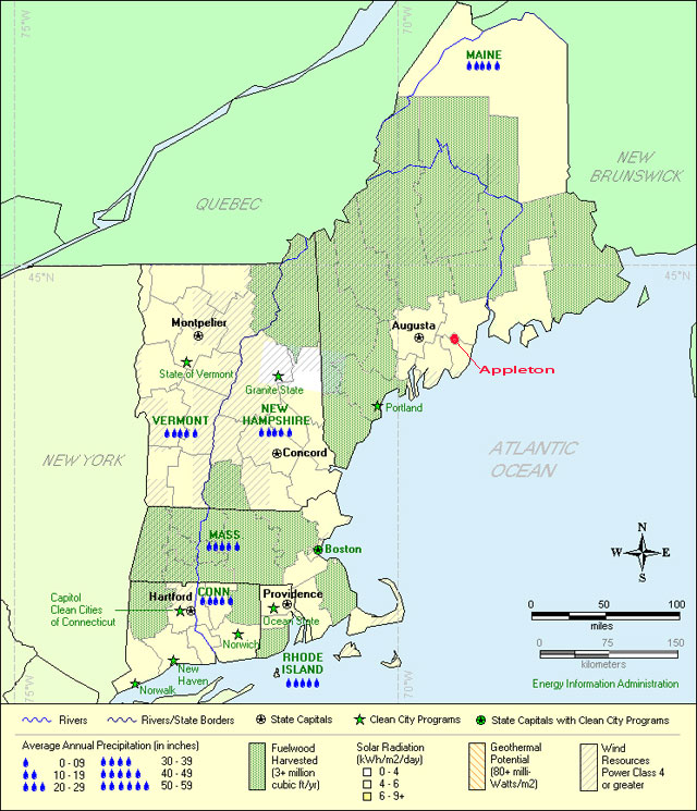
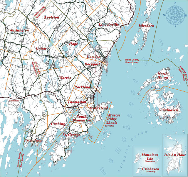
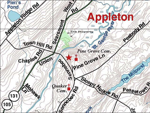
Appleton, Maine
|
|
|
|
|
Click on a map to enlarge...
|
|
Closest airport: Owls Head/Rockland (RKD) Served by Cape Air From Boston and Points South: On entering Maine at Kittery in the south, continue northward on Interstate 95 (same as the Maine Turnpike in southern Maine) for about 50 miles to the Portland area. At Portland, take the Interstate 495 (formerly I295) loop through the city, joining I295 (formerly I95) near Falmouth at exit 11 (formerly exit 15). Continue north on I295. Do NOT take the Maine Turnpike (I95) to Augusta. Take I295 towards Falmouth, Yarmouth, Brunswick, and Augusta. Stay on I295 North; do NOT take scenic US Route 1 towards Bath (unless you want to). Driving to Union from the Portland Airport, you would miss the shortcut I495 loop, getting onto I95/Maine Turnpike northbound at exit 45 or 48 (formerly exit 7 or 8). Get off the Turnpike at exit 52 (formerly exit 9) and get onto I295 towards Brunswick and Augusta. On I295, about 50 miles north from Portland and before Augusta, take exit 51 (formerly exit 28) and go east on US Route 9 to the business district of Gardiner. As you enter the city of Gardiner on Route 9, you will turn left over the Cobbosseecontee Stream at the traffic lights across from the Post Office (there is a cute old-fashioned "A-1 Diner" built right on the bridge). In a few more blocks you will be at the Kennebec River. Leave Route 201 and go straight over this large bridge (over the Kennebec River, now on Routes 27 South and 126 East). While on the bridge, get into the right lane and turn right after crossing the bridge (so you are on the east side of the Kennebec River, heading south). Go about a quarter mile and turn left onto State Route 226 North (at the auto body shop on left side). This is poorly marked: if you get to Pittston, you missed the turn! Drive north on Route 226 until it T's into Route 17 at Abbot's Market & Deli (you must turn right or left). Turn right onto Route 17 and go eastward towards Rockland for about 30 miles, through Cooper's Mills, Windsor, Washington and then to Union. As you come into Union from the west (you will not see the town itself because Route 17 bypasses to the north of the town common) you will see the John Deere dealer and Union Farm Equipment at the junction of Route 17 and Route 131 North. You can't miss the Kubota sign and the many pieces of equipment visible from the road. Turn left onto Route 131 after the John Deere sign but before Kubota sign, at the Maritime Farms station. From Route 17: From Route 17: On the west side of the town of Union (you will not see the town itself because Route 17 bypasses to the north of the town common) you will see big signs for the John Deere and Kubota/New Holland farm equipment dealerships on the north side of Rt. 17. Turn northward onto Route 131, right between the John Deere and Kubota dealerships. The next town northward on Route 131 is Appleton, about five miles. Go north from Union on Route 131, past Sennebec Pond on the right, and bear right where Route 105 leaves Route 131, staying on combined Routes 131 and 105 northbound past the Appleton Village School, which is on the left. When you reach the village of Appleton (signs say to slow to 25 mph) you will see a few small houses, then a white-steepled church on the left (well, the steeple started leaning in 2003, so it's set on the ground now, in the north churchyard). The Captain's Keep is on the right (east) side, just past the church. It's a traditional white-painted Cape-style farmhouse with attached barns and a detached large hay barn in the fields.
From Camden/Rockport:
|
|
The Land | Structures | Extras | History | Town & Schools | Local Links | Renovation Album | Home | Tay's Bio Home ---------------------------------------------------------------- •••> Description | Plot Plan | Maps | Photo Gallery: The Land <••• |
|
© Copyright 2007, Tay Vaughan Portions © Copyright Timestream® All rights reserved |